In 1995 I spent a month in Panama with the Army building roads and schools. Fuertes Caminos.
I spent most of my time in two towns – La Honda and Los Chorros. Thanks to the magic of Google Maps I can see the locations I went to. My favorite of these was Los Chorros where I spent most of 2 weeks living in an ambulance.
I’ll post more pictures of my trip from when I was 19 years old. I was super skinny back then.
Here is the google map link
https://www.google.com/maps/@8.9462532,-80.0650806,582m/data=!3m1!1e3
I just happened to find these photos of the school in the background.
https://www.facebook.com/pg/amilcartopo/photos/?tab=album&album_id=202906306535655
A = where helicopters would land from basecamp
B = a walk bridge where I was photographed putting up a rope line for the Missouri National Guard newsletter
C = the schoolhouse I’d visit and talk to the kids about Missouri – there was a girl there named Mixuri – they liked to comment on that a lot
D = where the Ambulance was parked – or very close any way.
E = the school we built and put a metal roof on
F = the cantina – there’s a bridge between the heart and the cantina. Someone had a chemlight that broke open and a drunk Panamanian screamed “El Diablo” and jumped off that bridge for where ever he was going to get to.
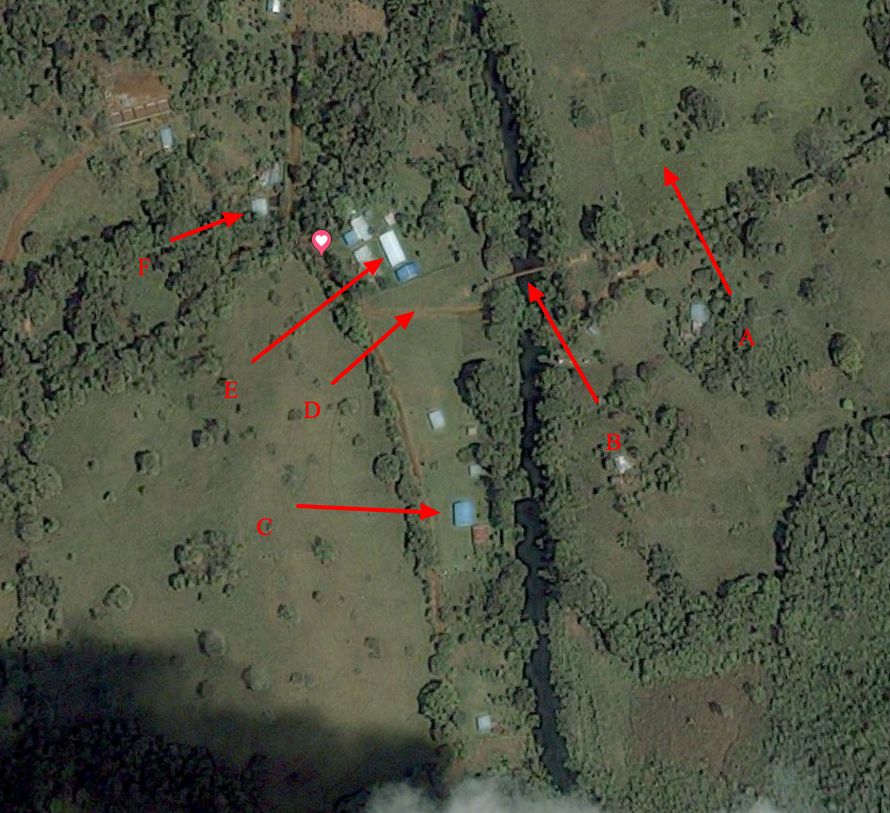
The river wasn’t too deep. It was just deep enough that I floated from the roadway by the walk bridge (B) down around the corner. Over by A, we’d get the fruit of the ice cream bean tree.
This location, at the time, maybe even today should I ever revisit, was my favorite on Earth.
